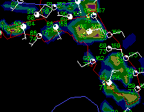
Close up of the surface plot for 15 Jul 1995
Close up of the surface plot for 15 Jul 1995
[Text Data]
[Severe Weather]
[Tropical Atlantic]
[Upper Air Data]
[Radar Data]
[Satellite Imagery]
[Model Output]
[ Server References]
[ Why this Page?]
Meteograms are a time-series plot of observed conditions, and can show at a glance interesting events (frontal passage, precipitation events, fog, cloud cover, and wind shifts, among others).
The Gulf Buoys and Costal Stations provide observations at remote sites similar to those of surface land stations, and are used in much the same way.
The meteograms are from Unisys, the Gulf Buoys and Costal stations are provided by FSU and the National Weather Service Office, Tallahassee. The surface maps from Unisys's WXPweather server.
| Surface Maps | Meteograms | Gulf Buoy/Costal Stations |
|---|---|---|
| Current | St. Louis | Cape San Blas |
| -1 Hour | Jacksonville | Buoy 42003 (e. Gulf) |
| -2 Hour | Atlanta | Buoy 42001 (c. Gulf) |
| -3 Hour | Dallas | Buoy 42002 (w. Gulf) |
| -4 Hour | New Orleans | Buoy 42007 (Mississippi Coast) |
| -5 Hour | Kansas City | Cedar Key |
| -6 Hour | Washington-Dulles | Keaton Beach |