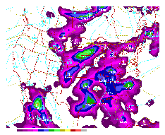
The 12 hour surface ETA forecast valid 00Z 15 Jul 1995. Shaded contours indicate predicted precipitation. Lotsa rain!
The 12 hour surface ETA forecast valid 00Z 15 Jul 1995. Shaded
contours indicate predicted precipitation. Lotsa rain!
[Text Data]
[Severe Weather]
[Tropical Atlantic]
[Surface Data]
[Upper Air Data]
[Radar Data]
[Satellite Imagery]
[ Server References]
[ Why this Page?]
| Numerical Models: Aviation (AVN), Eta (ETA) and Nested Grid (NGM) | |||
|---|---|---|---|
| Initial analyses | AVN | ETA | NGM |
| Surface | AVN | ETA | NGM |
| 1000 mb | AVN | ETA | NGM |
| 850 mb | AVN | ETA | NGM |
| 700 mb | AVN | ETA | NGM |
| 500 mb | AVN | ETA | NGM |
| 300 mb | AVN | ETA | NGM |
| RH/Lifted Index | AVN | ETA | NGM |
| 48 hour Total Precipitation | AVN | ETA | NGM |